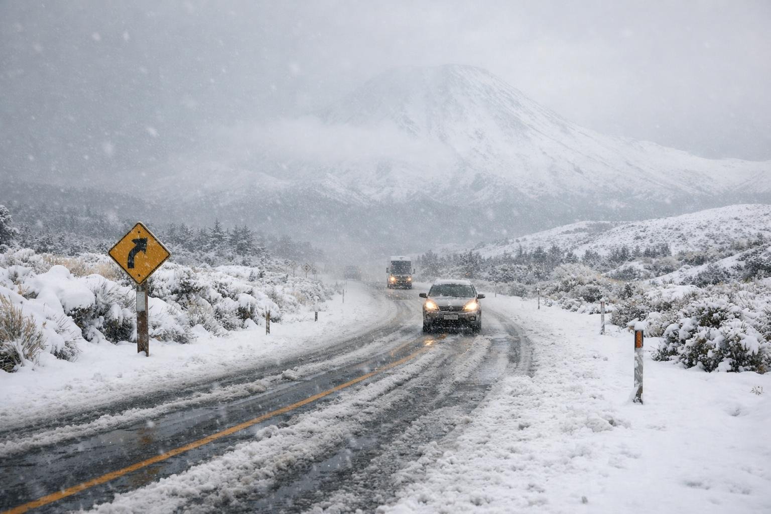
A surge of polar air has spilled across the central plateau, turning one of Aotearoa’s highest highways into a winter corridor. Thick flakes have piled onto the tarmac and tussock, retreating only when ploughs rumble through, then returning in fresh bursts that swallow road markings and shoulder posts.
Forecasters say the pulse isn’t done. With colder air still funneling north and moisture riding in behind, the storm’s teeth are sharpest over elevated routes, and commuters are being asked to shift plans, not just their speedometers.
Travel disruption and closures
Authorities report intermittent closures, escorted convoys, and delays as crews grit and plough the high passes. Waka Kotahi says ice is forming quickly once the sun drops, even where snowpack looks thin.
“We’re seeing snow settle on the carriageway in waves,” a Waka Kotahi spokesperson said. “When the band intensifies, visibility can fall to a few car lengths and we stand ready to shut sections at short notice.”
Truckies are pulling into lay-bys to wait for windows of safer travel. Some schools across the central plateau moved to remote learning, and intercity services are flexing timetables to dodge the worst of the whiteout conditions.
What the Orange Warning means
MetService has ramped up to an Orange Warning, signalling a meaningful risk of disruption, particularly for exposed, elevated corridors. In the New Zealand colour scale, Orange is a heads-up that impacts are likely and plans should change accordingly.
As one MetService meteorologist explained: “Orange is when we want people to start acting, not just watching. If your trip is flexible, move it. If it isn’t, prepare like you’ll hit ice and poor visibility, and expect closures.”
Here’s how the warning levels stack up:
| Warning level | Likely hazards | Typical duration | Advice for road users |
|---|---|---|---|
| Yellow (Watch) | Passing snow showers, brief slick patches | Short, changeable | Check updates, carry warm gear |
| Orange (Warning) | Persistent snow, icy roads, whiteouts | Several hours to a day | Delay travel, chains or avoid high routes |
| Red (Severe) | Major snowfall, prolonged closures, blizzards | Many hours to multi‑day | Essential travel only, shelter in place |
The current setup leans toward prolonged bursts of heavy snow above the plateau, with snowfall rates that can outpace road clearing during peak bands.
Conditions on the ground
Drivers describe a road that transforms minute to minute. One motorist who crested the high point before daybreak said, “It went from wet to slushy to full-on powder in about two kilometres. The wind pushed the car sideways where the cuttings funneled the gusts.”
Emergency services are urging conservative speeds, extra following distance, and an acceptance that arriving late beats not arriving at all. “People underestimate wind chill and how quickly a slide can happen,” a central North Island police sergeant noted. “If your windows are fogging, your brakes are cold, and your tyres are hard, you’re three decisions from a tow.”
Preparing for the next 24 hours
If travel is unavoidable, treat the plateau like an alpine pass, not a regular motorway. Key steps:
- Pack layers, water, snacks, and a fully charged phone with a car charger
- Carry a scraper, torch, and a small shovel; clear all glass before moving
- Lower speed and use gentle inputs; avoid cruise control on slippery surfaces
- Keep headlights on low beam in snow; high beams can reflect and blind
- Watch for graders and ploughs; give them space to work
- Check live road cameras, MetService warnings, and Waka Kotahi updates before departure
These basics are not optional when the road surface alternates between wet, slush, and compacted snow. A few minutes of prep can turn a risky crossing into a manageable one.
Alternatives and timing
If your route can flex, consider threading around higher summits by timing travel for daylight and lighter bands. Lower-elevation detours often buy you degrees of temperature and fewer ice traps, even if they add kilometres and minutes.
Public transport operators are staggering departures to follow clearer spells identified by forecasters. If you can hitch your plan to one of those windows, do it. The plateau tends to “breathe” through events like this—hard bursts, then brief lulls. Use the lulls.
The immediate outlook
Forecasters expect another pulse of snow showers this evening as colder air deepens. Wind chill will bite, and any melt will refreeze into black ice after dark. The signal for improvement strengthens late tomorrow, when showers fragment and road crews can get ahead of accumulations.
Until then, the advice from MetService and roading authorities is simple and firm: respect the elevation, respect the warning, and move only when you’re ready. As the Waka Kotahi spokesperson put it: “If you can wait, wait. If you must go, go geared up. The mountain writes the timetable in weather like this.”